STB to Prepare EIS for Proposed Eagle Pass Rail Line (UPDATED)
GER, a non-carrier subsidiary of Texas-based Puerto Verde Holdings (PVH), is developing the proposed line as an element of PVH’s proposed Puerto Verde Global Trade Bridge, which would “create a new trade corridor for freight rail and Commercial Motor Vehicles (‘CMV’) extending from the City of Eagle Pass to the U.S./Mexico border and then approximately 17.79 miles into the Mexican State of Coahuila,” GER reported in a Dec. 15, 2023, filing seeking STB approval of line construction.
GER told the STB that the purpose of building and operating the proposed 1.335-mile line is “to develop an economically viable solution to meet the needs for border infrastructure improvements that will increase safety and facilitate crucial binational trade between the United States and Mexico.”
GER said the existing border crossing in the City of Eagle Pass is the second busiest rail crossing between the U.S. and Mexico. It noted that currently rail traffic crosses the U.S./Mexican border at Eagle Pass via a single-tracked bridge belonging to UP on the U.S. side and owned by the Mexican federal government with rail operations concessioned to Ferrocarril Mexicano, S.A. de C.V. (Ferromex) on the Mexican side of the border; BNSF also operates on the line via trackage rights. Additionally, GER said, the current Eagle Pass Port of Entry rail bridge “is situated within the congested areas of the City of Eagle Pass, and Piedras Negras, Coahuila” and traverses nine at-grade rail crossings in the City of Eagle Pass and 16 at-grade crossings in Piedras Negras.
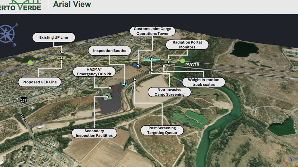
GER told the STB that it intends to construct and operate in Maverick County, Tex., a “double-tracked corridor with no at-grade crossings extending from the interchange point with UPRR [Union Pacific/UP] at approximately UPRR milepost 31 on the Eagle Pass Subdivision near the UPRR Clark’s Park yard extending 1.335 miles southwest and ‘terminating’ at the U.S./Mexican border on a newly constructed bridge that crosses the Rio Grande River. Further, GER would build infrastructure along the Proposed Line for U.S. and Mexican customs operations to include a customs control tower located between the Proposed Line and the CMV, providing for combined multi-modal cargo inspection.”
Because the proposed rail line has the potential to result in significant environmental impacts, STB’s Office of Environmental Analysis determined that the preparation of an EIS is appropriate pursuant to the National Environmental Policy Act, the STB reported March 29. Issuance of the Notice of Intent (download below) began the scoping period, the first step of the environmental review process.
The Office of Environmental Analysis was accepting comments on the scope of the EIS, including alternatives and issues to be analyzed in the EIS, until April 29, 2024. It held three public scoping meetings: two in-person on April 16, 2024, and one virtual on April 23, 2024.
After the close of the scoping comment period, the Office of Environmental Analysis reviewed all comments and addressed them in the July 8 edition of the Federal Register (see below).
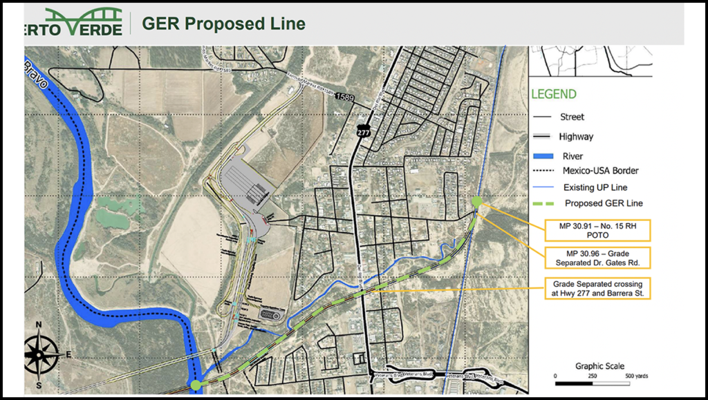
Additionally, the STB in the Federal Register provided the alternative routes to be analyzed (see map below or click here for an interactive version). They are:
• “Proposed Action (Southern Rail Alternative), GER’s preferred route. GER originally proposed a route that would have diverged from the UP mainline at approximate milepost 31, crossed Seco Creek, curved to the south of Seco Creek on an embankment, crossed over Rodriguez Street, Barrera Street, and U.S. 277 (Del Rio Boulevard) using bridges with an embankment in between, traversed an undeveloped area, crossed Seco Creek in two locations, and continued to and across the Rio Grande River. On June 27, 2024, GER sent OEA a letter modifying its original route. The modified route departs the UP mainline at the same location as the originally proposed route and follows the same route as the original route until the crossing over U.S. 277. West of U.S. 277, the modified route curves slightly to the south of the originally proposed route to avoid potential impacts associated with crossing Seco Creek and continues to and across the Rio Grande River. This route is now GER’s preferred alternative route.”
• “Northern Rail Alternative. Based on information obtained through the scoping process (including data collection, technical evaluations, and an additional site visit), OEA developed the Northern Rail Alternative as another reasonable build alternative for consideration in the EIS. The Northern Rail Alternative would follow a similar route as the Southern Rail Alternative from the UP mainline to U.S. 277 but diverge to the north approximately 0.1 mile west of U.S. 277 to minimize visual impacts to the residences south of Seco Creek. The Northern Rail Alternative would cross Seco Creek slightly to the north of GER’s originally proposed route, continue straight, and curve to cross Seco Creek and the Rio Grande River on the Rail Bridge. Under this alternative, the Rail Bridge would be located a little farther north than the Rail Bridge associated with the Southern Rail Alternative.”
The Draft EIS, which will discuss the potential environmental impacts of the proposed project and set forth the Office of Environmental Analysis’s preliminary recommendations for appropriate mitigation measures is expected in second-quarter 2025; the Office will request public comments on the draft and will hold public meetings after the draft is issued. The Final EIS is scheduled for fourth-quarter 2025 release.
The STB’s final decision and all required permits are necessary before construction can begin. The Office of Environmental Analysis anticipates the following permits and authorizations would be required to construct and operate the Line and the Puerto Verde Global Trade Bridge project:
- Clean Water Action Section 401 certification and Section 402 and 404 permits.
- Rivers and Harbors Act Section 9 and 10 permits.
- Endangered Species Act Section 7 compliance.
- National Historic Preservation Act Section 106 compliance.
- International Boundary and Water Commission authorization for work in the bed
and bank of the international stretch of the Rio Grande. - Presidential Permit. This permit of authorization was released May 31 (download below).
- Texas General Land Office (GLO) easement authorization for the bed of the Rio
Grande to the international boundary line. - Maverick County development permits, including a floodplain development permit.